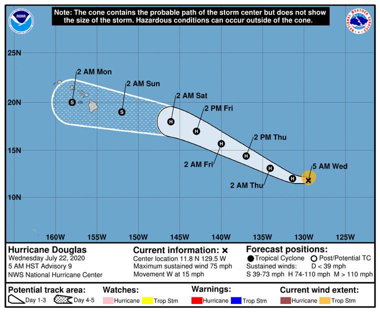
Hurricane Douglas — the first hurricane of the 2020 Eastern Pacific season — is expected to move near or over portions of the Hawaiian Islands this weekend, forecasters said Wednesday morning.
The storm’s current track brings an increasing chance that strong winds and heavy rainfall could affect portions of the state beginning on Sunday, forecasters cautioned.
As of 11 a.m. Wednesday, Douglas was spinning 80 mph winds and tracking west at 16 mph approximately 1,690 miles east of Hilo, according to the National Hurricane Center in Miami, which will monitor the storm until it crosses 140 degrees west longitude, at which time the Central Pacific Hurricane Center in Honolulu will assume the role.
Hurricane-force winds currently extend outward from the center of the storm up to 10 miles while tropical-storm force winds reach outward up to 105 miles.
Additional strengthening is forecast over the next day or two. Forecasters expect Douglas to peak mid-day Thursday as a Category 2 storm packing 110 mph winds more than 1,200 miles east of the islands.
On Friday, once the storm has crossed into the Central Pacific, which is where Hawaii is located, forecasters expect Douglas will begin weakening as it encounters cooler waters.
By 5 a.m. Sunday, Douglas is expected to be downgraded to a tropical storm with 70 mph winds approximately 200 miles east of Hilo. The current forecast track takes the storm right over the Big Island into Monday.
The next advisory will be issued at 11 a.m.


